Saturday, September 30, 2006

Squatter-Mimicry


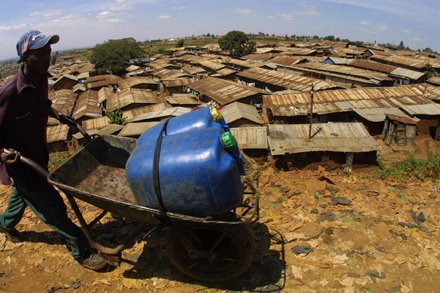
[Image: Kibera, in Nairobi, Kenya is one of the largest slums in Africa. Photo by SIMON MAINA/AFP/Getty Images]

Business Week has a short interview with Stewart Brand, whose recent research is focused on how the world's squatter cities are serving as centers of entrepreneurship and innovative design. The bulk of his message, (of which he has presented in numerous city conferences entitled ‘City Planet’, and is revealed in a long piece he published in a recent issue of Strategy + Business), in essence, describes the incredible pace of change facing the planet undergoing hyper-urbanization, and how cities reveal an evolutionary societal spirit in terms of the ways nature and civilization have - and go on - mutually shaping one another through out history.


[Image: Squatters in Bombay provide low-cost pots to restaurants through out the city. Photo by SEBASTIAN D'SOUZA/AFP.]

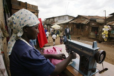
In short, Stewart is optimistic about an urban future, arguing that cities have a smaller footprint than rural development and therefore have the potential to be more compatible with environmental justice, and, particularly how squatter cities can be overlooked as critical mechanisms for the triumph of global poverty over rampant and helpless urban slumification.
Alex Steffen noted these thoughts from one of his talks, and wrote for Worldchanging:
“In asking himself how cities "learn" over time in the way that buildings do, Stewart found that while cities do learn, they also teach: they teach civilization how to be civilized.” [...] Stewart argues that the "squatter cities" which form in rapidly-urbanizing areas are among the most vital parts of the 21st century city. He asserts that these global slums and shantytowns are, for most residents, temporary, that pockets of urban poverty are transitions from even worse rural poverty to a better existence in the city. Squatter cities are usually self-constructed and self-organized, better reflecting the needs of the residents than government-built housing; they're also engines of community, where support is provided by extended family, neighbors and religious institutions."

In this interview, Brand himself says, “What's interesting is that nations have figured out that squatters simply aren't going away. They're realizing they have to be finessed rather than crushed.” He then compares the social movement of a squatter sustainability, to the open-source culture of the high-tech world. He says, “The street finds uses for things. The Internet is rife with things people are doing for free. […] Squatters operate in the same way. Just getting by takes a lot of creativity. And now nations and businesses are seeing, perhaps thanks to the open-source movement, that everything that isn't a crime has an application.”
Of course, if you want a vast and vivid account of this squatter sustainability and the nature of entrepreneurship that is vital to the survival of these communities, Robert Neuwirth’s book is an amazing account. I am reminded of this statement he wrote on his blog not long ago: “Pretty much every squatter is an impoverished entrepreneur. Primitive proto-capitalism may not be fashionable, but it is one way to move squatter communities forward.” He also links to a report by Muhammad Yunus, titled ‘ELIMINATING POVERTY THROUGH MARKET-BASED SOCIAL ENTREPRENEURSHIP’, which is a valuable read.


[Image: Kibera, Kenya. Photo by SIMON MAINA/AFP/Getty Images.]

Reena Jana, whom interviews Brand, asks some good questions: how squatter communities might provide useful models for other contexts of needed self-construction, like disaster response; how squatters could be trend setters for a future world where resource is scarce, where government assistance is meager, where density is overwhelming, and where communities will need to become increasingly independent and entrepreneurial for their own survival. The article veers more towards an interest in how the informal economy is, or perhaps will more so in the future, serve and intersect with the formal economy, and how businesses should be looking to find more ways of working with squatter communities.


[Image: Erecting shelters near Manila, where often times the environment alone is the biggest hazard for squatters. Photo by JOEL NITO/AFP/Getty Images.]

I wish Brand’s responses explored more deeply specific models squatters are devising by and for themselves; examples of a truly self-sustainable and self-reliant model of community building, independent progress, that doesn't require outside financial or infrastructural assistance. Pure squatter innovation.


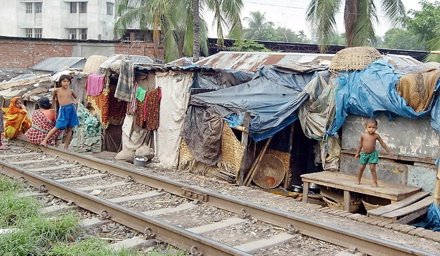
[Image: Scavaged housing in Dhaka, Bangladesh. Photo by FARJANA K. GODHULY/AFP/Getty Images.]

Indeed, squatters are some of the most resourceful people on the planet. For a good read with a lot of relevant resources on this topic of a squatter urbanism, check out this interview I did with Wes Janz, an architect and educator who has been working with deprived communities for years, following a sort of build to learn philospophy, whereby the squatters and refugees are understood as providing the architectural lessons of the future.
Also, check out Renu Khosla, who registers an official presence for slum dwellers in Delhi, by marking their existence down in chalked renditions of place and occupancy on the sidewalks. There's Jockin Arputham, head of the National Slum Dwellers Federation and Slum Dwellers International, who, as Neuwirth describes, is the world's only squatter philosopher. He "applies the tools of capitalism to a critique of capitalism. He sees savings as the salvation of the urban poor." In his model, "each squatter community that joins the federation creates a savings association." This allows communities to pool their money, which is returned to them in the form of small business loans, with very cheap interest rates. The results in India have been amazing, and only confirms that the agents of change for the urban poor are - and will be - the urban poor themselves.
Also, a great quote found in Shadow Cities, from a journalist describing the squatter homes in the early days of New York: "The shanty is the most wonderful instance of perfect adaptation of means to an end in the whole range of modern architecture. Nothing is prepared for it, neither ground for material. Its builders have an empirical knowledge of the craft they practice. They scorn a model, and they work with whatever comes to hand."
Given the unpredictable landscape of contemporary global urbanism, challenged by dramatic shifts in climate change and a spike in devastating natural disasters, the economic pressures of globalizationon on labor markets, the world economy and its translation to inaccessible real estate markets all over, and, given what seems the United States' heightened capacity to respond to any event only in terms of a security threat rather than with the needed compassion and capacity for true emergency relief and efficient long term disaster response planning, not to mention the decline of the middle class through out the First world, the increasing global divide between the developed world and a Third world trapped behind a threshold of borderzones, immigration surveillance scapes, and hyper-militarized buffer zones, we may all of us one day find ourselves standing on one side of a set of bars or another; that is, either isolated behind the iron clad bubble of a swollen gated community, or behind a flexible border fence that moves and adapts to an alteration in border territory disputes and land occupations, tactical annexations made ambiguous by perpetual conflict, a stasis grounds of hyper-migration, and the landscape rise of temporary camp-ification. It may very well spell a future world where the squatters and refugees will be the leaders of a self-sustainable revolution, a bottom-feeders' guide to survival and the retooling of cities on a global scale. It may be those very same principles of self-mobilization and scavenge that will save urbanization from itself.
Almost identitcal to something I wrote at the end of the Janz interview, Brand makes this righteous statement and coins a term I had not heard before. “Perhaps soon we'll be looking to squatter cities for design ideas, much as we looked to biology. Rather than bio-mimicry, we'll be considering squatter-mimicry.”

Wednesday, September 27, 2006

The Internal Fringes of America


[Image: One of five practice targets used by the Navy and Air Force in the Imperial Valley. Photo via The Center for Land Use Interpretation, and the New York Times, 2006.]

You can add this one to my bookshelf, to be sure.
CLUI (Center for Land Use Interpretation) has published a new book, a sort of field guide to their own intrepid and curiously vast survey of the American landscape over the last decade. We're talking military bombing ranges, a cathedral canyon, the Ave Maria Grotto, abandoned solar power plants, radioactive film location sites, surreal military training grounds, an Art Farm, historic ruins of secret WWII radiation labs, a ghost town theme park, and so on. Vast exurban tracts of industrial wasteland, clandestine military real estate, from black site cities to abyssal brownfield disaster zones, avant garde land art to subterranean networks of hydrological antiquity. Anyway, you get the picture. It's a tattered internal patchwork of America that goes on escaping the public eye.


[Image: The Desert Center. Photo via CLUI.]

Truly interested? Dive in to the database right here. "In researching the manmade environment," this recent New York Times article writes, "the center is often drawn to the frayed edges and forgotten margins of human sprawl: ghost towns, grim industrial zones, decaying waterfronts. At other times the group appears to be trying to locate and describe the precise middle of nowhere, somewhere out in the vast, open spaces that America sees fit for use only as hazardous waste dumps and nuclear test sites."
Come on, if you haven't already spent hours surfing CLUI's site, it's a fascinating glimpse of all sorts of secret real estate battles waged under the public's nose, or sometimes even right out in the open, and reads more like a performance art encylopedia of land use freakshows than a simple archive. It's the cult classic of American novels the average Joe never even knew about much less bothered to read; a constellation of bizarre landmarks, informal cultural heritge sites, and overlooked historic monuments that not only were designed to elude the radar altogether, but which depict the psychic underbelly of the American landscape where secrecy is the law of the land, and where refuge serves as a sinister camoflage so that nature's sublime becomes a surreptitious canvas for a whole unsuspected typology of 'out of sight, out of mind' geomorphologic renditions. It is the America that's been left up to an odd breed of crypto-geographers to reveal the hidden complexions of a built landscape and natural environment braided and functioning together as one evolving landscape narrative of inevitable human impact.
Speaking with with Matthew Coolidge - the CLUI founder and editor of the book entitled "Overlook", he says, “I suppose it can seem idiotic, but our approach really is to stumble across something and say: ‘What is that? What is it for? How did it get there?’ We try not to draw conclusions. A conclusion is the end of the journey. Learning happens along the way.”
Well, sorry if I pretentiously drew any conlusions, but don't let that stop you from checking out the book should you come across it on someone's bookshelf one day.

Sunday, September 24, 2006

Cities as Impostors


What would be the blast effect of a ground-level, shallow subsurface, or low-altitude nuclear weapon detonating on your city? Well, FAS has provided a nifty little tool just for you to see. Check out the Nuclear Weapon Effects Calculator. “Using High definition aerial maps of selected U.S. cities”, you can “select the size of the bomb according to the weapon's yield, as measured in kilotons (KT) or megatons (MT) of TNT equivalent.” You can also select “the option of having the bomb delivered using an automobile at ground level or using an aircraft flying at an altitude that produces the widest area of destruction.”
The color coded radial blast rings define the different damage states that would emanate, from widespread fires to homes that would be completely incinerated, from stronger commercial buildings that would sustain severe damage to an expanding atmosphere of flying debris smothering the region.
For something so simple, I have to admit it’s pretty freaky to actually see nuclear devastation in these terms, on this scale, especially on a little city like San Francisco, which would be utterly annihilated by a single blast, to say the least. Oh the power of visualization. For more technical data, refer to this report: "Nuclear Weapons in the 21st Century". Clive suggests sensationalizing the effect further by immersing us in a full-on game world of nuclear destruction, that would surely recalibrate our understandings of the sheer urban halocaust of a nuclear fallout.


On a slightly different transposed tip, Paula Levine at Banff asks, what if international gestures, such as acts of terrorism or war, were like boomerangs and returned to sites of origin with an impact equal to the one enacted? So, she put together a project which considers tracts of devastated landscapes juxtaposed over other "places untouched by such traumatic forces of changes." The objective, she writes, is to create a series of "hypothetical mappings" that "imagine the impact of political and cultural changes that take place in one location, upon another. These 'turns of force' templates allude to a hybrid space whereby an imaginary territorial cultural overlay allows us to ponder the historic and destructive legacies of impacted places compared to other places through a unique relationship of projected and superimposed equilateral devastation.
For example, Levine uses San Francisco, long referred to as the Baghdad by the Bay, as a template for remapping the initial bombing campaign of Baghdad, Iraq. In these nodes of destruction, a new sense of both spaces emerges...


Now, if you want to take that concept even a step further, say, to put it on a first-person level point-of-view, read Regine's dispatch from her walk through Brooklyn along the You Are Not Here trail: an urban tourism mash-up which invites participants to become meta-tourists on an excursion through the city of Baghdad while walking through the streets of New York. With maps, mobile devices, and a good pair of walkng shoes, she writes, "You Are Not Here tries to expose the contrasts and the similarities between two mashed cities. We are consuming global information on a daily basis: a tourist visit demands a higher level of commitment and identification with a place than a habitual commute. YANH provides participants with a fragmented tourist experience, which provokes a critical view of urban space and its subjection to media and politics."
It would be amazing one day to travel the world this way, exploring multiple cities at once, every where you went. Just punch in a city code into your mobile phone, and voila, a map appears of any city you wish to tour, coordinates and audio guides superimposed over a map of whatever city you are in. I realize this seems counter touristic in some sense, a weak attempt to visit cities without actually visiting them, but as a way of exploring cities that mimic each other, like-cities with scaled geographic and architectural similarities, or tours of cities that no longer stood, or proposed cities; destroyed cities, forbidden cities, liminal cities, secret cities.
For instance, I go visit Boston and take a tour of destroyed Beirut, or go to Burning Man and take a psuedo-tour of Area 51. An abandoned shopping mall in Colorado turns into a psychogeographic meander through NORAD, a remote Utah landscape becomes a template for a terrestrialized glimpse of a future lunar colony.
They could make a cheap version of Amazing Race out of it, instead of crawling around the world through real cities, contestants navigate a superimposed world of historic clues, transposed monuments, layered non-places, imaginary landmarks, navigating a hyper-urbanism of stacked cities and confused urban makeovers. Blah blah blah, I have no idea. But cities cloaked in invisible wardrobes, alleyways wearing ski masks, cities posing as other cities, cities as impostors, performance buildings and ventriloquist architecture, clues given and misgiven by street signs that existed and did not exist, multiple sets of simultaneous temporal data - to be in two or three cities at once - toggling back and forth from the Tiananmen Square to Trafalgar Square to the Champs D'Elysee, all without ever leaving downtown Manhattan. Some crazy reality show street game travelling the world all within in a single city.
Ok, whatever, obviously, there is still a lot that needs to be worked out - like the fun factor, I suppose - so I will drop this for now.

Tuesday, September 19, 2006

Padua's Berlin Wall


[Image: The wall built on the outskirts of Padua to seal off the Serenissima housing estate. Photograph: Marco Bruzzo/EPA - Guardian, 2006.]

Padua is an old city in Italy, home to one of Europe's oldest universities where Galileo once taught mathematics and historic artworks were produced by greats like Giotto, Donatello and Mantegna. Today, unfortunately, it has earned "the distinction of having the most dangerous housing development in northern Italy." Others have stated, it is "the worst possible example of failed integration." The issue is how this quiet old city has turned into an urban ghettosphere by a massive influx of African migrants in the last few decades, for whom the local economy has failed to accomodate. Right now, according to this article, some 210,000 people live in Padua, of whom 20,000 are legally resident non-EU citizens. A further 30,000 non-EU residents live in the surrounding province, which has a total population of almost a million. There are also several thousand asylum seekers, all hoping to be given leave to stay. But Padua has become a crime ridden urban battlezone between rival gangs, drug dealers, and populations of migrants who still lack the ability to work in Italy legally, to vote, and are essentially lost in an endless line waiting for some form of national legalization.
So, instead of critically re-examining the neccessary legal mechanisms for managing the multi-ethnic fabric of a modern Padua society, officials, in just a few hours, erected a msssive steel wall at the outskirts of Padua, to further isolate the ghettosphere of the Serenissima housing estate from nearby residents who felt threatened by an atmosphere of constant violence. Described as "a large and ugly barrier stretching for 84 metres, three metres high and made of thick steel panels, there is a police checkpoint at the entrance as well as CCTV cameras."
Critics are equating it to the concentration camps and Jewish ghettos created by the Germans decades earlier, and saying this action is a "surrender to criminality." Is it simply using militarization as a crutch, an apartheid-like segregation out of convenience?
The social solidarity minister Paolo Ferrero had this to say:

"The title of today's "Corriere della Sera" makes one think that I proposed to build walls and ghettos in all cities. This is not only false but completely contrary to the proposal I presented in an assembly of hundreds of immigrants in Padua on Sunday. [...] The initiative of the Padua town administration I positively commented was the project of the closure of the Via Anelli ghetto by way of finding accommodation for its inhabitants in other parts of the city: all this with the full consensus of the immigrants and the support of the town's social services. This positive policy dismantling ghettos and favouring social integration should be adopted also in other cities to resolve similar situations. The "wall" was actually built because during this dismantlement of the ghetto a conflict with the inhabitants of confining buildings exploded; moreover they tried, in this way, to limit the massive presence of drug dealers".

Nevertheless, the wall won't solve their problems in this city or any other for that matter. So, what legal means do they plan on examining - and quickly - to deal with the core social implications of ghettoization and immigrant isolationism? Where is that debate, and will the immigrant community be there, or too trapped behind this wall to attend?

Saturday, September 16, 2006

Peripheral Milit_Urb 10


[Image: Egypt/Israel border. Photo by Patty Brdar.]

MIDEAST MILIT_URB

Israel’s Border with Egypt to be Sealed with Electronic Fence: Israel is expecting to tighten security measures along the southern end of the Egyptian/Israeli border by erecting an electrical fence from its most southern tip extending the north for 12 kilometers (7.44 miles).

Lebanon claims Israel encroaching on its territory with new barbed-wire fence: U.N. peacekeepers asked Israel's army on Wednesday to pull down a new barbed-wire barrier that Lebanon said encroached on its territory, but Israel denied it was on Lebanese soil – a test of the month-old cease-fire.

The Great Wall of Arabia: No, you won't be able to see it from space, but Saudi Arabia, unnerved by the violence next door in Iraq, plans to spend up to $7 billion on a partly virtual fence along its 500-mile border with Iraq. The ultramodern barrier will combine fencing, electronic sensors and sand berms. Saudi and U.S. sources tell TIME the kingdom is seeking bids from contractors, including U.S. defense giant Raytheon. (A Raytheon spokesman says the Saudis asked the company not to comment.)

GAZA LIGHTS OUT: For the past two months, Gaza residents like Aqdeir have lived without a regular supply of electricity after the Israeli military bombed Gaza's only power station on 28 June.

Restoring Kabul's lost beauty: The return of millions of refugees has pushed up property prices in the city, and dozens of large, square blocks, with blue or green mirrored windows, have been built with remarkable speed. Most are far from the centre, but that could change. "They want to put up shoddily-built, cheap, multi-storey buildings which don't retain anything of what is so wonderful about Old Kabul," Mr Stewart says.

Iraq to Dig Trenches Around Baghdad: Iraqi security forces will dig trenches around Baghdad and set up checkpoints along all roads leading into the city to reduce some of the violence plaguing the capital, the Interior Ministry said Friday. The security plan, known as Operation Together Forward, began June 15 and is being implemented in three phases. The first phase included setting up random checkpoints around the city, phase two began Aug. 7 and focused on the most violence-prone areas of Baghdad — mostly the Sunni Arab southern districts. Phase three reportedly includes cordoning off and searching other parts of Baghdad, including predominantly Shiite areas.


[Image: The Mehdi Army controls Shoula, with its armed guards stationed at checkpoints around the area. It is one of the biggest militias in Iraq and is allied to the radical cleric Moqtada Sadr. See other pics in the BBC's photojournal Iraq's neighbourhood patrols.]


Military Training Goes Hollywood (by David Axe): To better prepare its troops for tough counterinsurgency warfare, the U.S. military is investing in super-realistic exercises that combine traditional live-fire training with sophisticated cultural instruction and Hollywood-style special effects that blur the lines between training and combat.


[Image: Missile Radar M.I.A.: Defense Tech looks at the Missile Defense Agency's Sea-Based X-Band Radar, or SBX. The $815 million, 28-story, orb-like contraption that has become one of the centerpieces of the Bush Administration's revamped anti-missile strategy, after it took office.]

In the Iraqi war zone, US Army calls for 'green' power: To minimize 'serious' casualties, a top commander in Iraq is calling for renewable energy to reduce demand for petroleum to fuel generators at US outposts. That, in turn, would reduce the number of vulnerable fuel convoys, such as these entering Kuwait. The US Army's Rapid Equipping Force (REF), which speeds frontline requests, is "expected soon" to begin welcoming proposals from companies to build and ship to Iraq 183 frontline renewable-energy power stations, an REF spokesman confirms. The stations would use a mix of solar and wind power to augment diesel generators at US outposts, the spokesman says.

Future Be Warned: Keep Out!: A half-mile below the surface of the New Mexico desert, the federal government is interring thousands of tons of monstrously dangerous leftovers from its nuclear weapons program --plutonium-infested clothing, tools and chemical sludge that will remain potentially lethal for thousands of years to come. It may be safely secured now, but how to keep our descendants centuries in the future from accidentally unearthing it?


[Image: At the Bank of America tower in Midtown, stairwells exceed city code standards. They are reinforced concrete and are wider than required. Photo by Ángel Franco/The New York Times (2006).]

FORTRESS URBANISM:

9/11 Has Spurred Only Modest Changes in New York City and National Building Codes
The indestructibles: The Freedom Tower at Ground Zero could be the world's most attack-proof building. Is this the future of urban design?
How Wall Street became secure, and welcoming
Federal buildings don armor of nation under siege
What price security? Architecture in an anxious age
Security and Terrorism: Lessons Learned from September 11
Building a skyscraper after 9/11
Terror threat fails to stem high-rise boom. Defensive measures focus on fortifying buildings' bases against possible attack

The Price of Eternal Vigilance
: University of British Columbia geographer Elvin Wyly and journalist Mitchell Gray, in describing how American cities have been cast within a "terror city hierarchy", state that,

"[a]ssaulted with officially sanctioned warnings of constant, evolving threats emanating from cities and villages across the globe, residents of American cities may acquiesce to the current logic of the Project for a New American Century: pre-emptive war to eliminate all possibilities of challenges deemed by the American state as unacceptable in a unipolar world. But another scenario is possible, as American urbanites come to understand that city fortifications against 'global' threats fail to keep terror out: such measures only succeed in hiding and justifying American state-sponsored terror in Iraq and elsewhere, in bringing new and more virulent forms of insecurity into the American city, and weaving the metropolis into a destabilized, insecure global urban system of risk."

McMansions, underground, ready for war.


ARCH< ART< OTHER:

An Architektur: Increasing social tensions, cultural capitalization, ethnic segregation, ubiquitous surveillance, and the privatization of public space within the context of urban re-development strategies dictated by neo-liberal economic thinking demand a new critical approach in spatial practice.


[Image: 1987 Honda Civic, 300 lbs ANFO explosive.(Energetic Materials Research and Testing Center (EMRTC), New Mexico Tech, Socorro, NM) 2005. Archival pigmented inkjet on paper, 63X42 inches. Paul Shambroom, SECURITY SERIES.]

Homeland security: Paul Shambroom's photography series 'Security' examines issues of fear, safety and liberty in post-9/11 America.
Orwellian projects: One of the works that received an honorary mention at the prix ars electronica in the Net Vision category is Tracking Transience: The Orwell Project, a collection of photographs with a web based companion that tracks Hasan M. Elahi and his movements in real-time, from the last meal he ate to the last public urinal he visited.

The U.S. Army Permafrost Tunnel: Between 1963 and 1965, the U.S Army Permafrost Tunnel was dug "entirely within frozen ground on the north slope of Hill 456 near Fox, Alaska."

Wednesday, September 13, 2006

'Urbanites of Surveillance'


[Image: The Panoptic C-Thru 3D Video Surveillance System (via Gizmag)]

In all of his meanderings, Polo – now a Second Life migrant – came upon the abrupt outskirts of a naked and unrendered metropolis; a see-through city completely devoid of texture, where an androgynous biopolitical skeleton of moving parts [laborers, machines, vehicles] connected this totalitarian network of unshaded polygons in the vast atmospheric maw of game world plainness. The city’s infrastructure – now reduced to a heap of unexceptional models – was further subordinated by its own apparent invisibility, so that everything piped through it like monitored bits of proletarian automata seen laboring through the arterial view of some ambiguously dimensional vascular urban core.
Walls were obsolete. Instead, these urbanites pretended to obey mere placeholder representations of them, or, at least basic linear insinuations of their shapes; a deceptively intuitive society completely abiding by an invisible architectural corpus of authority.


[Image: Transparent New York, by Brian McGrath.]

This virtual metrosphere itself was a three-dimensional atlas of implicit borderzones and ideal spacio-surveillance proximities; an unsuspecting geometric landscape of intersecting planes, prefigured barrier relationships, controlled migration egress, and topographic cross sections of panoptic verticality.


[Image: The Transparent Room, a project by Michael Pinksy.]

Every nook and cranny, invisible corner, hidden cleft, sunken or elevated cubicle, every angle and non-angle of accountable urban space (corresponding exactly to an adjacent real world city somewhere on the globe), had become irrelevant, now that entire buildings were rendered transparent by a new security environment management system – better known as C-Thru – which was “effectively a complex form of Augmented Reality fusing real-world video imagery with volumetric models in a real-time 3D display.” With these scaled simulations, observers were enabled to comprehend multiple simultaneous streams of temporal data and imagery, in essence, watching entire cities with a single set of eyes.
Perhaps, the “Functioning Core” (theoretically) will one day be converted in to a meticulous 3D environment using this combination of imagery supplied by millions of “low-cost 360º cameras and dynamic background subtraction”, which, for all intents and purposes as the developers once explained, makes the walls of the world's buildings and vehicles translucent, “offering at-a-glance situational awareness of security-relevant people, objects and vehicles in motion.”


[Image: The Panoptic C-Thru 3D Video Surveillance System (via Gizmag)]

Imagine, whole cities digitized and exported into Second Life as perfect x-rays of themselves, gamers made optimal security agents for the global war on terror, the entire built world redevised online with its peopled guts exposed for all to see, all of us the urbanites of surveillance trapped in generated avatars of ourselves.
There, Polo found a future world designed to expose and admire itself, a city revealed only by its own omniscient view of itself. A narcissistic city made completely opaque so that everything could be seen and watched, scrutinized and tracked, matched in its own pale reflection; a city made in the image of a panoptic sublime. It all seemed the dream of a pervasive glance, the glance of a self-haunted city entertaining itself as the all seeing cyclopean narrator of its own techno urban spy novel. This time, Polo had found, quite virtually, an invisible city.

Friday, September 08, 2006

The Liminal Architects


Image via greg.org.

I originally posted this to Archinect, but am including it here, too. If you are in Vancouver near the end of this month, go check out Kyohei Sakaguchi's installation Zero Yen House. Based on his research of the informal architecture of Japan's urban homeless, and his book entitled the same, the exhibition will feature a portable dwelling that is evident of the clever and resourceful builders that inhabit the in-between spaces of Tokyo's cityscape.

From the Canadian Architect article: This work highlights a subculture that builds cleverly designed residences from the refuse of mainstream society for little or no money. The plans for these homes are often shared and the dwellings themselves are sometimes sold. By documenting the output of this creative subsection of homebuilders, Sakaguchi hopes to reveal an approach to architecture in tune with immediate needs and available resources.

Sakaguchi's Zero Yen House installation at the Vancouver Art Gallery explores and elaborates on his architectural research. As a central component, the artist will duplicate a home he discovered in 2000 on the banks of Sumida River in central Tokyo owned by a former engineer.


Reconstructed from the artist's detailed drawings of the original structure, this ingenious dwelling uses an inexpensive solar panel to supply energy for six hours of lighting, television and radio. The dwelling is collapsible and portable, possessing a structural plan that allows for accurate reassembly of every facet of the design.


Images of homes presented in the installation do not include the owners of the dwellings. Instead, Sakaguchi focuses on the structural peculiarities of the dwellings in order to highlight the distinctiveness of each owner's vision and their various strategies for building a house. By doing this, he seeks to reveal a form of architecture created with the instinct, consciousness and capability of human beings not guided by preconceived ideas.


These images via a littlemore.

And check out Nurri Kim's related photography Tokyo Blues. (via)


Tuesday, September 05, 2006

Mount Weather Gets a Little Facelift


I can think of no better person than Tom Vanderbilt to offer us a report on the current operations (as seen from as close up as possible) of the Mount Weather Emergency Operations Centre in Virginia’s Facquier County, just 75 miles west of Washington DC.

The complex, guarded by hillsides of forests, barbed wire, no trespassing signs, and roving Ford F-150’s driven by men with sunglasses, is run by the Federal Emergency Management Authority (Fema). But, unofficially, it is understood, Mount Weather “is a massive underground complex originally built to house governmental officials in the event of a full-scale nuclear exchange." Vanderbilt writes for the Guardian, "Today, as the Bush administration wages its war on terror, Mount Weather is believed to house a "shadow government" made up of senior Washington officials on temporary assignment.”


Sprawling across 500 acres, “it functions like a rump principality” he says, “with its own leaders, its own police and fire departments, and its own set of laws.” In an age of satellite omniscience and ubiquitous aerial surveillance, it is somewhat ironic that Mount Weather is apparently more easily viewed from outer space than right up close. In the beautiful Blue Ridge landscape, there is said to be two Mount Weathers: the Fema run facility, and the more clandestine “undisclosed location” that becomes signature of the Bush administration’s convoluted secrecy.

Vanderbilt’s guide Tim Brown is a national security researcher and aerial imagery expert. He points out some of the newer exterior landscape additions to the peripheral armor and shading of the complex: new black sheeting threaded through the border fencing to obscure views of the helipad, truck barriers installed at the entrance to slow vehicles down. “They got smart” he says. Signs of taking necessary security precautions in an era of elevated terrorist attacks, or more furtive gestures of an administration that prefers to conduct its political affairs in deeper enclaves devoid of any outside scrutiny? Either way, the locals agree, the centre’s activity hasn’t been more obvious since the days of Eisenhower.


Vanderbilt gives us a good glimpse of the facility’s - sketchy at best - publicly known history, and explains how a drilling exercise in the ‘50’s led the Army Corps of Engineers to a full on experiment in underground city building. “The base”, he tells us, “formed part of a "federal relocation arc", an archipelago of hardened underground facilities, each linked by a dedicated communications system and equipped with amenities ranging from showers to wash off nuclear fallout to filtration systems capable of sucking air clean down to the micron level. The sites, staffed by "molies", were spartan steel-and-concrete expanses, subterranean seats of power: the president could repair to Mount Weather; Congress had its secret bunker under the Greenbrier Hotel in Virginia; the Federal Reserve had a bunker in Culpepper, Virginia; the Pentagon was given a rocky redoubt called Site R in the mountains of southwestern Pennsylvania; while the nation's air defences were run out of Norad's (North American Aerospace Defence Command) Cheyenne Mountain facility.”


With the undergound bunker 'Raven Rock' in Pennsylvania, CLUI informed us back on 2002, these two facilities "function as the main relocation sites for the highest level civilian and military officials, and what is called, seemingly interchangeably, the "Continuity of Government" and the "Continuity of Operations Plan" (COOP). The present day version of this plan, when it is activated, as recent articles in national newspapers have claimed, calls for 75 to 100 government workers to be kept in one of two underground locations, briefed daily and prepared to take over if the active, elected government is wiped out. COOP was activated hours after the attacks on September 11, and since that time these unknown individuals have been serving in rotations lasting up to three months, in Raven Rock and Mount Weather."

On September 11th 2001, the congress was suspected of being shuttled to Mount Weather. In this new article, Vanderbilt speaks with some intriguing locals living nearby the facility, as well as some ex-government employees willing to share some of the highlights of their fascinating resumes (that is, if you are, say, a military spy novelist), who remark on some of the more curious and absurd historical traces of the facility's use, like, for instance, when the Russians were given by the State Department a tract of land there to use for their own R&R center. But, as open as some were to talk about Mount Weather from their own mysterious vantages, Vanderbilt finds a population of relatively sealed lips. However, the escalating activity, especially immediately following the 9/11 attacks, has some saying that it has only drawn more attention to the facility rather than to help strengthen it as any kind of secret refuge for the government. Nevertheless, no one has ever been inside has ever spilled any beans, and so, as usual, we can only wonder what government programs are ticking away in the subterranean vaults of the nation's capitol emergency operations station.

[See these earlier posts: Through the Turnstile; Touring the Greenbrier; Secret Cities of the A-Bomb; Area 71; Washington's New 'Survival City'; A Silo Full of Cash; Secret Soviet Submarine Base; Fortress Baghdad; The 'Long War' enters its capsule; Subterranean Urbanism; Tokyo Secret City; Bunker Archaeology; Smugglers' Paradise Uprooted; [Re] improvising sub_Base landscapes; Secret Synagogue; Mt. Seemore and the watchful gaze; from Leftover-Bunkers to Tourist-Traps...; A "Closed Atomic City": Open for Business]

Friday, September 01, 2006

carceral urbanism: San Pedro Prison (Bolivia)


Rafael Estefania produced this photo journal for the BBC on the notorious San Pedro Prison in Bolivia, a city within a city, where children are raised by their fathers in cells without bars, cells that still must be paid for by the inmates themselves; a prison urbanism with high end real estate where some cells can go for as high as $1,500 for a private bathroom, a kitchen, even a billiard space, and where other poor inmates are packed into tiny spaces together working for market stalls, as hairdressers, for restaurants, as tour guides. There is even a hotel for foreign visitors. "Home to about 1,500 inmates", Estefania writes, "it looks more like the streets of El Alto, Bolivia's poorest neighbourhood that sprawls on the outskirts of La Paz, than a prison."


Estafania reports: "Few of the inmates here are convicted killers - 80% of them are here for drug-related offences. Only about 25% of all prisoners are actually serving a sentence - the rest are awaiting trial." Nearly 200 children reside in the prison, the young ones attend 2 nurseries inside the prison city while the older ones go to school outside the secured walls and gates.


"Violence in San Pedro is relatively contained during the day, but things can get bad at night, when inmates steal from each other and fight with knives. The police do not go inside or interfere in any way. According to prison figures, there are about four deaths a month from both natural causes and "accidents". Prisoners are expected to resolve their own problems through section representatives elected democratically."


A few years ago, writer Rusty Young collaborated with photographer Niels Van Iperven on the book Marchng Power, which chronicled the wild culture of the prison through the true story of a British drug smuggler forced to serve his sentence in San Pedro. Their great photo journal can be viewed here.