An Apartheid Travel System
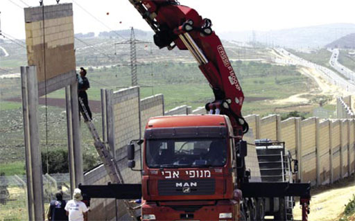
[Image: Construction of apartheid road in al Jeeb destroys Palestinian lands, Stop the Wall Campaign, 2006]
As the result of a recent Israeli High Court decision that approved the completion of the annexation wall around Jerusalem, “Stop the Wall” (the Grassroots Palestinian Anti-Apartheid Wall Campaign) reports on a new "alternative" road that is being built for Palestinians through the town of Al Jeeb north of Jerusalem, to devise an “Apartheid travel system” that will give the colonizers exclusive use over the original road in the area, which Palestinians have used for centuries.
“Settlers in Bet Horon, Giv’at Ze’ev and Giv’on Hdsha have used the road for decades (as well) as it enables them to connect to other Zionist colonies across Jerusalem.” With the new “alternative” road,” says the Palestinian activist group, “the Occupation seals the use of the historical road for Jews-only.”
After serving Palestinians with eviction orders to make way for demolitions in the south of Al Jeeb, the Occupation has already begun uprooting Palestinian farming lands in the area. “Over 200 dunums of Palestinian land are to be destroyed.” Furthermore, “This process will see more Palestinian lands in the West Bank destroyed – [and] in one area, Palestinians will be funneled under the colonizer road using a tunnel.”
"The bypass roads" writes Eyal Weizman, "attempt to separate Israeli traffic networks from Palestinian ones, preferably without allowing them ever to cross. They emphasise the overlapping of two separate geographies that inhabit the same landscape."
So, with an exclusive Jewish transit system and a parallel ghettoized infrastructure for the Palestinians, how is the issue of border territory and the sovereignty of passage managed?
Weizman goes on to explain, "Both the valley the road spans over, and the city it dives under, are areas handed over to limited Palestinian sovereignty under the Oslo accord. The physical separation is mirrored in a political one. As with the Temple Mount proposals, the ‘border’ stretches along a horizontal line. The city above is under Palestinian limited sovereignty; the road below it is within Israeli jurisdiction."
The UN even has a stake of jurisdiction in some of the underground spaces at certain depths, while the Palestinians remain completely surrounded, as Israel claims ownership of the air space over the West Bank.
This sort of sedimentary-layered power structure indicates the interwoven volumetric nature of political space that Weizman speaks of which constitutes a three-dimensional urbanism of occupation. "In the West Bank, bridges are no longer just devices engineered to overcome a natural boundary or connect impossible points. Rather, they become the boundary itself, separating the two national groups across the vertical dimension." More explanation can be read in the chapter Roads — over and under (The Politics of Verticality).
Read more on Eyal Weizman's work here.
posted by Bryan Finoki • Permalink
![]()
![]()


0 Comments:
Post a Comment
<< Home