Non-borders, Anti-borders, and the Run-on border
Another one I missed, this time in Toronto. Bummer. Though, I think the concept sounds a lot cooler than the actual photographs appear. However, I only have these three images to go by, so, I sure would have liked to check them out in person. Anyway.
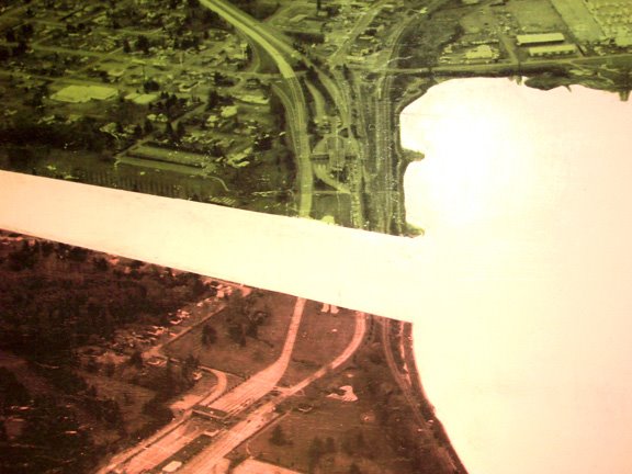
So, Nancy Duff has created a vision of a North American continent that treats the border in its absence by literally erasing them from the map, drawing an emphasis to the common geographies surrounding the voided border spaces, which she uses to sort of re-approximate the identities of Canada and Mexico neighboring a toxic super power like the U.S..
But, explaining it much better than I, the project [Borderdom] represents “the constant awareness of living next to the world’s super power. This double-edged reality is experienced asymmetrically, yet profoundly by the northern and southern neighbours of the U.S.; however, both neighbours perceive America’s projected anxieties without, perhaps, being seen to have differing points of view.”
The YYZ Artists’ Outlet describes the project further:
Through aerial views of the North American body as seen along its international borders, together with references to the undocumented and unregulated movement of people, pathogens, elements of “criminality,” and subversive ideas, BORDERDOM examines the veins and arteries of roadways and waterways that circulate the lifeblood of commerce and culture through the continental corpus. But is the body healthy? Are the bloodlines of North American life tainted with diseases like xenophobia, homophobia, cultural imperialism and conflicting interpretations of home and belonging?
These questions are filtered through a primarily Canadian perspective – if North America is the body, then Canada is its eyes and mind, the USA its beating heart, and Mexico its pumping legs. The eyes see, the mind considers, and the feet are swift – but what of the health of the hidden heart? Does the patriotic hand serve to strengthen the organ, or reinforce its isolation from the rest of the body? The so-called longest undefended border is examined with its NAFTA complement, as conflicted sites of cultural and economic inhabitation, influence, colonization, contamination and exchange.
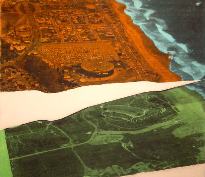
Peter Goddard for the Toronto Star calls Duffy’s aerial finalities “anti-borders”, and likens them to those innocuous strips that run down the center of the highway. Or even, the lane dividers. Sure they are borders, but they are not real barriers, but rather a broken chain of boundary prescriptions, or, an endless supply of implicit space striping the arterial landscapes of the continent’s migratory-sphere. And Duffy’s images kind of evidence the same, by reducing the political boundaries between nation-states in a similar sort of way, mocking them by removing them, almost to the point of being revealed as pure landscape fictions.
As hardened as the world's borders are becoming, how much of their existence stands as purely an imaginary boundary? A perceived border, an othering of place? And without the borders, what would be left in terms of geographic similarities, cultural (in)congruities, what is the essence of geopolitical division when the borders disappear?

But, part of what’s so interesting to me about the border is how it is such a locus of diversity; a site of conflict, yes, but also cultural explosion. So, as much as I would be interested in seeing this project on a global scale, I’d also love to see the opposite: a photographic collection of all the world’s borderzones themselves, to examine the similarities or differences of those demographics. Just like the world might look incredibly self-cloned in the absence of the borderzone, how corresponding might all of these separate borderzones look when framed out of context and placed next to each other, side-by-side in one run-on string of aerial shots? One run-on border geography?
Anyway, I'm not exactly sure what I'm saying, but I sure would like to catch this project somewhere, and maybe bust out Google Earth and try building an endless comparative borderzone cartography of my own. Whatever.
[All images by Nancy Duff, BORDERDOM, 2006.]
posted by Bryan Finoki • Permalink
![]()
![]()


0 Comments:
Post a Comment
<< Home