The Sectarian Faultlines of Baghdad

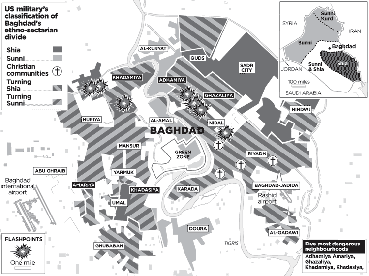
[Image: I wanted to pass on a map I came across released by the U.S. Military in Iraq, which (in their own image) classifies Baghdad's ethno-sectarian divide based on 'the five most dangerous neighborhoods' according to their degrees of explosivity: Adhamiya, Amariya, Ghazalya, Khadamiya, and Khadasiya. The map comes from a pretty interesting article in the London Times, describing the capital city for what the occupation has let it become: that is, an absolute jungle that's been carved into a jagged chess board of volatile neighborhood faultlines where Sunni and Shia gangs have sealed off enclaves within enclaves of turf rivaling for political power. Urban Baghdad is almost completely dissected by a feral matrix of informal checkpoints, sniper alleyways, car bombed corridors, networks of micro insurgent-urbanisms; it is the city re-engineered by endless dueling barricades of postcolonial control; it is, above all, a scrappy imperial abyss. Bagdhad's guillotined real estate is a stage for indiscriminant slaughter, for militant dominance - blood trails in the streets mark a kind of demographic authority as much as they do the absence of an authority altogether. And it makes me ask, in all irony, where is Saddam's Iron Fist now when the American's need it most? (Thanks to MoJo for spotting this).]


0 Comments:
Post a Comment
<< Home